
Munnar is one of the most visited hill stations in Kerala, India. Most tourists know about its tea gardens and cool climate. But very few people know that Munnar hides some truly breathtaking waterfalls deep inside its forests and valleys. These waterfalls are not marked on popular tourist maps. You will not find them in typical travel packages. Yet, they are some of the most beautiful spots in all of Kerala.
This article will take you through the hidden waterfalls of Munnar, the exact routes to reach them, and all the travel tips you need to plan a safe and memorable trip.
Why Visit the Hidden Waterfalls of Munnar
The popular waterfalls in Munnar, such as Attukal and Cheeyappara, are always crowded. They are located along highways and are easy to reach. Because of this, they have lost a lot of their natural charm. The hidden waterfalls, on the other hand, are tucked away in forest land. You need to walk a bit, sometimes trek through tea estates, and sometimes cross small streams. But the reward is worth every step. You get clean, quiet, untouched nature all to yourself.
If you love photography, trekking, or simply being in nature without the noise of crowds, these hidden waterfalls are perfect for you.
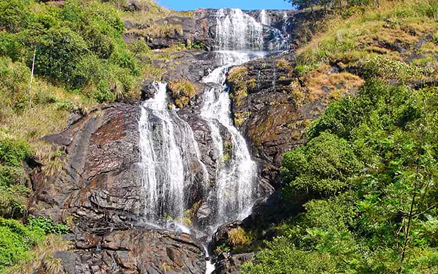
1. Kolukkumalai Waterfall
Location: Near Kolukkumalai Tea Estate, Top Station Road, Munnar
Distance from Munnar Town: Approximately 38 kilometres
Difficulty Level: Moderate
Best Time to Visit: June to November
About the Waterfall
Kolukkumalai is famous for being one of the highest tea estates in the world. But just below the estate, hidden inside the rocky slopes, is a small but powerful waterfall that very few visitors ever see. The water comes from the streams that flow across the tea garden and drops sharply into a narrow gorge below.
The sound of this waterfall can be heard before you see it. The surrounding area is covered with short tea bushes and wild grass, giving the whole place a very green and fresh look.
Exact Route to Kolukkumalai Waterfall
Starting Point: Munnar Bus Stand
- From Munnar town, take the road toward Top Station. This road is well-marked.
- After about 32 kilometres, you will reach the Kolukkumalai base village called Suryanelli.
- From Suryanelli, you need to take a jeep (the road is very steep and rough, not suitable for regular cars). Jeeps are available for hire at the base.
- The jeep will take you up to the Kolukkumalai Tea Estate entrance.
- From the estate entrance, walk along the left trail for about 1.5 kilometres down the slope.
- You will hear the waterfall before you reach it. Follow the sound through the shrubs.
Google Maps Search Term: “Kolukkumalai Tea Estate Suryanelli” — from there, ask locals for the waterfall trail.
Tip: Go early in the morning. The jeeps fill up fast, and the walk is more pleasant in cooler weather.
2. Chinnakanal Waterfall (Power House Waterfall)
Location: Chinnakanal Village, 22 kilometres from Munnar
Distance from Munnar Town: Approximately 22 kilometres
Difficulty Level: Easy to Moderate
Best Time to Visit: July to January
About the Waterfall
Chinnakanal waterfall is locally called the Power House Waterfall because of an old hydro power station nearby. This waterfall is much larger than most people expect. It falls from a height of nearly 2000 feet in multiple stages through thick forest. The base of the waterfall is inside a valley, and the view from the top is absolutely stunning.
This place is not promoted heavily on tourism websites, which is why it remains relatively quiet even during peak tourist season.
Exact Route to Chinnakanal Waterfall
Starting Point: Munnar Town Centre
- Take the road from Munnar toward Bodimettu (NH 85).
- Drive for about 18 kilometres. You will pass through Adimali town.
- Shortly after Adimali, look for the left turn toward Chinnakanal village. There is a small signboard, but it is easy to miss. Look for it near the 22-kilometre marker from Munnar.
- Drive into Chinnakanal village for about 3 kilometres.
- You will reach a small parking area near the old power house building.
- From the parking area, follow the stone path downhill for about 800 metres. The path is clear and easy to follow.
- The waterfall will come into view after a sharp right turn in the path.
Google Maps Search Term: “Chinnakanal Power House Munnar” — navigate to that point and the trail begins right there.
Tip: The last stretch of the path can be slippery during heavy rain. Wear proper footwear with grip.
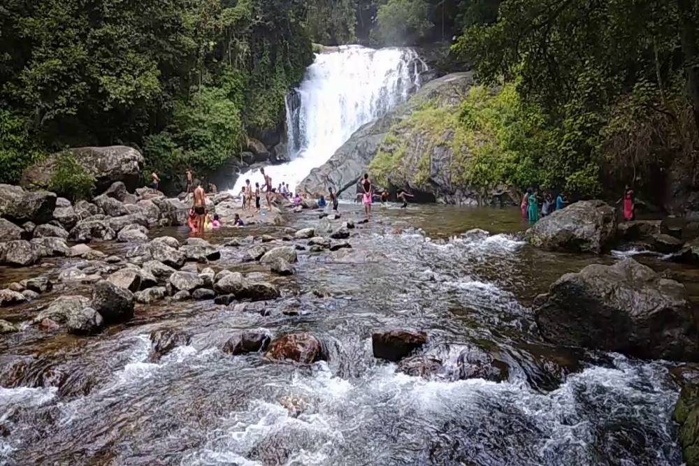
3. Lakkam Waterfall
Location: Near Marayoor, 40 kilometres from Munnar
Distance from Munnar Town: Approximately 40 kilometres
Difficulty Level: Easy
Best Time to Visit: August to February
About the Waterfall
Lakkam waterfall is one of Munnar’s best-kept secrets. It is located near the Chinnar Wildlife Sanctuary, on the road toward Marayoor. The waterfall is surrounded by dry deciduous forest, which is very different from the green tea estates that Munnar is usually known for. This gives it a completely different look and feel compared to other waterfalls in the area.
The water here is crystal clear and the pool at the base is shallow enough for visitors to stand in safely. The forest around it is home to various birds, making it a great spot for birdwatching as well.
Exact Route to Lakkam Waterfall
Starting Point: Munnar Town
- Take the road from Munnar toward Marayoor. This is a well-paved and scenic road that passes through several tea estates.
- After about 35 kilometres, you will enter the Chinnar Wildlife Sanctuary buffer zone.
- Look for the Lakkam Wayside Amenity Centre on your left side. This is a small structure with restrooms maintained by the Kerala Forest Department.
- Park your vehicle at the centre. The waterfall is just 200 metres inside the forest from this point.
- A short and easy walking trail leads directly to the waterfall.
Google Maps Search Term: “Lakkam Wayside Amenity Centre Munnar” — the trail starts right at this location.
Tip: There is a small entry fee collected by the forest department. Carry cash as there is no digital payment facility here.
4. Pettimudi Waterfall
Location: Near Pettimudi Village, Rajamala Road
Distance from Munnar Town: Approximately 18 kilometres
Difficulty Level: Moderate (requires short trek)
Best Time to Visit: September to December
About the Waterfall
Pettimudi is known mostly as a village that suffered a tragic landslide in 2020. However, the surrounding area still has significant natural beauty. There is a hidden waterfall near the upper reaches of the Pettimudi hills that flows strongly during and after the monsoon season. This waterfall is inside estate land, and very few outsiders know about it.
The view from near this waterfall includes sweeping views of tea estates on one side and thick forest on the other.
Exact Route to Pettimudi Waterfall
Starting Point: Munnar Town
- Take the Rajamala Road from Munnar (the same road that leads to Eravikulam National Park).
- After about 15 kilometres, take the left fork toward Pettimudi village instead of continuing to Rajamala.
- Drive carefully as the road narrows significantly here. Drive for about 3 kilometres into the village.
- Park your vehicle near the tea estate office.
- From the office, ask the local workers for the trail to the upper waterfall. They are generally helpful and will point you in the right direction.
- The trek to the waterfall takes about 40 minutes through the estate and a section of forest.
Google Maps Search Term: “Pettimudi Kerala” — navigate to the village and ask locals for guidance from there.
Tip: Do not attempt this trek alone. The path is not clearly marked and it is better to go with at least one local guide.
Best Time to Visit Hidden Waterfalls in Munnar
The best time to visit these waterfalls is between July and January. During the monsoon season (June to September), the waterfalls are at their fullest and most powerful. From October to January, the water flow remains good while the weather becomes more comfortable for trekking.
Avoid visiting between March and May when most waterfalls reduce significantly or dry up completely due to summer heat.
General Travel Tips for Visiting Hidden Waterfalls in Munnar
- Always carry enough drinking water. These spots are remote and shops are far away.
- Wear sturdy shoes with good grip. The terrain near waterfalls is almost always wet and slippery.
- Do not enter the water if the current looks strong. Flash floods can happen quickly in forest areas.
- Carry a physical or offline map on your phone as mobile network coverage is poor in several of these locations.
- Inform someone at your hotel about your plan before heading out.
- Avoid carrying plastic. These places are pristine and must stay that way.
- Start your visits early in the morning to make the most of daylight and avoid afternoon rains.
How to Reach Munnar
By Road: Munnar is well connected by road from Kochi (130 km), Coimbatore (160 km), and Thekkady (90 km). State and private buses run regularly from all these cities.
By Rail: The nearest railway station is Aluva (110 km from Munnar). From Aluva, take a bus or taxi to Munnar.
By Air: The nearest airport is Cochin International Airport (Nedumbassery), about 110 kilometres from Munnar.
Final Thoughts
Munnar has much more to offer than what most travel guides show. Its hidden waterfalls are nature’s own secret gift to those who are willing to explore a little beyond the obvious. Whether you are a solo traveller, a couple, or a family that loves the outdoors, these waterfalls will give you memories that last a lifetime.
Plan your visit carefully, respect the forest and the local communities, and you will experience a side of Munnar that most tourists never get to see.
Pack your bags, lace up your shoes, and go find those hidden waterfalls. They are waiting.
Read Also: Hidden Munnar Spots for Couples and Photography Lovers

Sunil Singh is a dedicated travel content writer and the founder of MunnarTeaGardens.in. He specializes in creating comprehensive, user-friendly guides on Munnar’s tea gardens, hill stations, and Kerala tourism. Drawing from the latest tourism trends, official sources, and visitor experiences, Sunil helps thousands of travelers plan safe and rewarding trips every year.